不动产登记代理人《地籍调查》试题及答案2023

聚题库
05/24
<p>&nbsp; &nbsp;不动产登记代理人《地籍调查》试题及答案2023已经整理好,需要备考的朋友们赶紧来刷题吧!</p> <p><img style="display: block; margin-left: auto; margin-right: auto;" src="https://img2.meite.com/questions/202305/24646ddd04e53b9.png" alt="" /> &nbsp;【单选题】<br />&nbsp; &nbsp;1.初始权属调查的()是查清行政辖区内申请登记的全部宗地的权属、用途等。<br />&nbsp; &nbsp;A、原则<br />&nbsp; &nbsp;B、宗旨<br />&nbsp; &nbsp;C、依据<br />&nbsp; &nbsp;D、目的&nbsp; &nbsp;<br />&nbsp; &nbsp;答案:D<br />&nbsp; &nbsp;解析:初始权属调查即调查人员对县及县以上某一行政辖区内申请登记的全部宗地进行全面现场调查,以核实宗地的权属,确认宗地界址的实地位置并掌握土地利用状况。<br />&nbsp; &nbsp;【单选题】<br />&nbsp; &nbsp;2.在宗地图变更时,原宗地图的处理方法是()。<br />&nbsp; &nbsp;A、直接在原宗地图上划改,继续使用<br />&nbsp; &nbsp;B、复制原宗地图保存,直接在原宗地图上划改<br />&nbsp; &nbsp;C、原宗地图不得划改,加盖&ldquo;变更&rdquo;字样印章保存<br />&nbsp; &nbsp;D、复制原宗地图,在复制宗地图上划改&nbsp; &nbsp;<br />&nbsp; &nbsp;答案:C<br />&nbsp; &nbsp;&nbsp; &nbsp;【单选题】<br />&nbsp; &nbsp;3.法律上没有特殊规定的森林资源属于()所有。<br />&nbsp; &nbsp;A、森林所在的市(县)人民政府<br />&nbsp; &nbsp;B、森林的栽种者及其继承人<br />&nbsp; &nbsp;C、在森林旁居住的全体公民<br />&nbsp; &nbsp;D、国家&nbsp; &nbsp;<br />&nbsp; &nbsp;答案:D<br />&nbsp; &nbsp;解析:《中华人民共和国森林法》第三条规定:&ldquo;森林资源属于国家所有,由法律规定属于集体所有的除外。国家所有的和集体所有的森林、林木和林地,个人所有的林木和使用的林地,由县级以上地方人民政府登记造册、发放证书,确认所有权或者使用权。森林、林木、林地的所有者和使用者的合法权益,受法律保护,任何单位和个人不得侵犯。&rdquo;<br />&nbsp; &nbsp;【单选题】<br />&nbsp; &nbsp;4.下列各项属于变更地籍调查需要准备的表格的是()。<br />&nbsp; &nbsp;A、变更登记申请书<br />&nbsp; &nbsp;B、有关的界址点坐标<br />&nbsp; &nbsp;C、变更地籍调查通知书<br />&nbsp; &nbsp;D、变更调查所用的文具&nbsp; &nbsp;<br />&nbsp; &nbsp;答案:C<br />&nbsp; &nbsp;&nbsp; &nbsp;【单选题】<br />&nbsp; &nbsp;5.勘测定界最后成果体现于技术报告书,下列各项不属于技术报告书内容的是()。<br />&nbsp; &nbsp;A、勘测定界技术说明及勘测面积表<br />&nbsp; &nbsp;B、界址点坐标成果表、界址点点之记<br />&nbsp; &nbsp;C、勘探界址线成果图<br />&nbsp; &nbsp;D、勘测定界表和土地分类面积表&nbsp; &nbsp;<br />&nbsp; &nbsp;答案:C<br />&nbsp; &nbsp;解析:勘测定界最后成果体现于技术报告书。技术报告书内容有勘测定界技术说明、勘测定界表、勘测面积表、土地分类面积表、界址点坐标成果表、界址点点之记和用地地理位置图。将上述内容按目录、表格、说明、略图等装订成册。<br />&nbsp; &nbsp;【单选题】<br />&nbsp; &nbsp;6.除特殊需要外,原则上可以不进行变更地籍测量,直接应用测量结果的是()。<br />&nbsp; &nbsp;A、宗地分割<br />&nbsp; &nbsp;B、调整边界新增界址点<br />&nbsp; &nbsp;C、宗地合并且没有增设界址点<br />&nbsp; &nbsp;D、新增宗地&nbsp; &nbsp;<br />&nbsp; &nbsp;答案:C<br />&nbsp; &nbsp;解析:宗地合并不重新增设界址点的,除特殊需要外,原则上可不进行变更地籍测量,直接应用原测量结果。<br />&nbsp; &nbsp;【单选题】<br />&nbsp; &nbsp;7.城镇土地利用现状调查工作需要进行大量的空间统计和分析,如果原来的GIS系统难以胜任,应选用更高级的GIS系统作为分析平台,但必须实现两个GIS平台之间的()数据转换。<br />&nbsp; &nbsp;A、无损<br />&nbsp; &nbsp;B、奇数<br />&nbsp; &nbsp;C、无差别<br />&nbsp; &nbsp;D、高速&nbsp; &nbsp;<br />&nbsp; &nbsp;答案:A<br />&nbsp; &nbsp;解析:城镇土地利用现状调查工作涉及的范围广、数据量大,需要进行大量的空间统计和分析,如果原来的GIS系统难以胜任,应选用更高级的GIS系统作为分析平台,但必须实现两个GIS平台之间的无损数据转换。<br />&nbsp; &nbsp;【单选题】<br />&nbsp; &nbsp;8.对于城镇街坊外围界址点及街坊内明显的界址点,其检查距离与原勘测距离较差允许误差为()cm。<br />&nbsp; &nbsp;A、&plusmn;15<br />&nbsp; &nbsp;B、&plusmn;10<br />&nbsp; &nbsp;C、&plusmn;7<br />&nbsp; &nbsp;D、&plusmn;5&nbsp; &nbsp;<br />&nbsp; &nbsp;答案:B<br />&nbsp; &nbsp;解析:检查距离与原勘测距离较差的中误差及允许误差如表5-1所示。
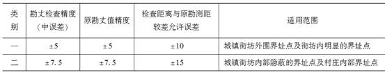
<img src="https://img2.meite.com/questions/202205/206286ff0b75b2a.png" /><br />&nbsp; &nbsp;【单选题】<br />&nbsp; &nbsp;9.违约缺席者对权属调查结果如有异议,须在收到调查结果之日起,()日内重新提出划界申请,并负责重新划界的全部费用。<br />&nbsp; &nbsp;A、10<br />&nbsp; &nbsp;B、15<br />&nbsp; &nbsp;C、20<br />&nbsp; &nbsp;D、30&nbsp; &nbsp;<br />&nbsp; &nbsp;答案:B<br />&nbsp; &nbsp;解析:权属调查时,对指界人缺席或不在地籍调查表上签字的,可按下面规定处理:①如一方缺席,其宗地界线以另一方所指界线确定;②如双方缺席,其宗地界线由调查人员根据现状及地方习惯确定;③将现场调查结果及违约缺席指界通知书送达违约缺席者。违约缺席者对调查结果如有异议,须在收到调查结果之日起,15日内重新提出划界申请,并负责重新划界的全部费用。逾期不申请者,则①、②两条确定的界线自动生效。<br />&nbsp; &nbsp;【多选题】<br />&nbsp; &nbsp;10.关于出让国有土地使用权,下列各项属于其权属来源证明材料的有()。<br />&nbsp; &nbsp;A、勘测定界图件<br />&nbsp; &nbsp;B、建设用地批准书<br />&nbsp; &nbsp;C、新开工大中型建设项目土地预登记文件<br />&nbsp; &nbsp;D、土地使用权出让金缴纳证明<br />&nbsp; &nbsp;E、《国有土地使用权出让合同》&nbsp; &nbsp;<br />&nbsp; &nbsp;答案:BDE<br />&nbsp; &nbsp;解析:出让国有土地使用权是指经县级以上人民政府批准,以出让方式取得宗地一定年期的国有土地使用权。出让国有土地使用权权属来源证明材料有:建设用地批准书、《国有土地使用权出让合同》、土地使用权出让金缴纳证明等权属证明材料。</p> <p>&nbsp; &nbsp;<span style="color: #0000ff;">更多【不动产登记代理人模拟考试卷】练习&mdash;&mdash; <u><a style="color: #0000ff;" href="https://www.wet35.com/shijuan/695_0_1.html">https://www.wet35.com/shijuan/695_0_1.html</a></u></span></p> <p><img style="display: block; margin-left: auto; margin-right: auto;" src="https://img2.meite.com/questions/202304/07642fca498cb51.png" /></p>
相关题库